Sick of your camera roll being clogged with project photos? A new AI-powered technology allows users to “look behind the wall” without endless phone scrolling.
PlanRadar – a leading digital construction, real estate and facilities management platform based in Austria – has launched a new feature to streamline visual documentation of ongoing building projects.
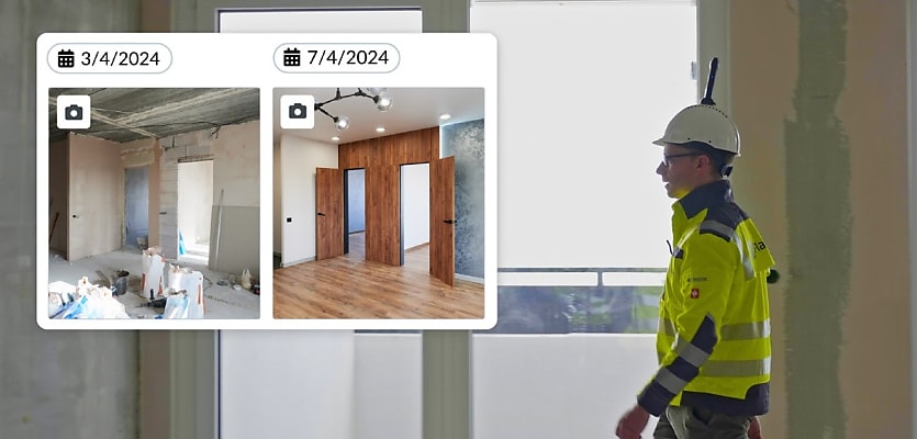
Before, photographic documentation was often haphazard, with individual builders and project managers taking “thousands of individual photos” that could be difficult to find later on.
PlanRadar’s new feature, SiteView, aims to replace the disorganised systems of the past with a “meticulous visual archive of project progression at every phase of development”.
Construction teams walk through a site with a 360-degree camera attached to a helmet. SiteView then automatically transfers the photographs to an app and integrates them into a 2D plan of the site.
A “compare” feature allows side-by-side image comparisons of the same location at different stages of development.
“This feature’s a game-changer for PlanRadar users,” said group co-CEO Ibrahim Imam. “In addition with our core documentation, communication and ticketing platform, SiteView means anyone working on a project can now easily go back and look ‘behind the wall’ to see exactly what was built or installed, often reducing rework.”
Imam stated that the feature’s “easy-to-use experience” combined with high levels of accuracy would make it possible for users to “achieve complete visual as-builts and field, progress and photo documentation.”
According to the company, SiteView uses simultaneous localisation and mapping (SLAM) technology, the very same technology that is used in driverless cars. This technology allows SiteView to “meticulously survey unfamiliar environments while in motion”, with AI-powered computer vision algorithms integrating “depth estimation and accurate localisation”.
Leon Ward, digital construction specialist for Australia and New Zealand at PlanRadar, stated: “SiteView reduces on-site inspection time and speeds up team collaboration, allowing a complete view of the site, even when working remotely.”
“360-degree photographic images provide all the documentation needed to see what has happened, delivering complete project transparency,” said Ward.
“With minimal training required, users simply set a starting position on a 2D construction plan within the PlanRadar mobile app, walk the site, and press stop when finished; our sophisticated algorithms take care of the rest.”
SiteView is currently preparing for its initial launch, with PlanRadar stating that “ongoing updates” will soon follow. On the future agenda are building information modelling (BIM) integration, among other proposed changes.
Make Real Estate Business a preferred news source on Google.
